Ohinemuri Regional History Journal 43, September 1999
Gold Mining at Waihi Beach, 1898 to 1910
By P R Moore
[This article was published in the "Historical Review", the Journal of the Whakatane and Tauranga Historical Societies. It is reproduced here with the permission of the Editor of the "Historical Review" and of the author.]
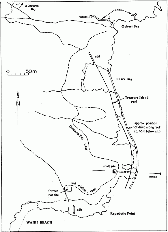
Location of mining related features, and the Treasure Island Reef, on the headland north of Waihi Beach.
Sinking on the Treasure Island Reef
Ohinemuri Regional History Journal 43, September 1999
The existence of quartz veins in the area north of Waihi Beach was known as early as 1870, but not much prospecting was done until 1894-96. Traces of alluvial gold were found in nearly all the streams as far north as Homunga Bay, and several adits were driven in along some of the larger veins exposed in the steep coastal cliffs. The only recorded production, however, is from two tons of ore extracted by Shaw and party from what was known as the Treasure Island Reef. This bulk sample apparently assayed at 2oz. of gold per ton, and returned £14.
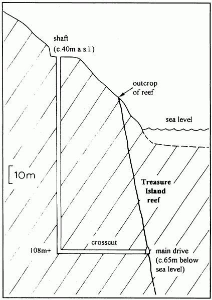
Section through the main shaft and crosscut of the Mine.
Sinking on the Treasure Island Reef
Ohinemuri Regional History Journal 43, September 1999
Obviously encouraged by this return, some of the prospectors amalgamated their claims in 1898, to form the Waihi Beach United Goldmining Company, with the intention of testing the area more thoroughly. They were primarily interested in the Treasure Island Reef, which outcropped in several places along the rocky coast and consisted of "kindly looking quartz" up to 3 feet 6 inches in width. This large reef was thought to continue northward for a considerable distance.
During the years 1900 to 1902 very little work was done on the property, apart from driving prospecting adits into the steep cliff faces, presumably in the hope of finding other promising quartz veins. Unfortunately no payable ore was encountered, and in 1903 the company decided that the only option was to sink a shaft to test the Treasure Island Reef at greater depth. By 1904 workers' huts, a blacksmith's shop, and other buildings had been erected in the vicinity, and equipment procured in preparation for sinking the shaft.
The shaft was sited on the headland at the north end of Waihi Beach, at an elevation of about 40 metres above sea level.
In order to provide sufficient space for all the equipment and materials, a level area approximately 20 metres by 10 metres had to be formed by cutting into the steep hillside. A road was also constructed up to the site.
It was intended to sink the shaft to a depth of 330 feet (100 metres), then extend a crosscut tunnel eastward for about 150 feet (46 metres) to intersect the main reef well below sea level. By the end of 1905 the shaft, which measured 4 feet by 3 feet, had been hand dug to a depth of 30 metres, and the company had installed a 14 h.p. Tangye engine and boiler to continue the work. About six men were employed at this time.
An incidental view of the northern headland at Waihi Beach, circa 1905-10, showing the Waihi Beach Goldmining Company's shaft headframe and associated powerhouse with its twin chimney stacks. The nearby hut (directly above the figures) may have served as a blacksmith's workshop and assay house.
During 1906 sinking of the shaft was completed, reaching a depth of 356 feet (365 feet in some reports), at which level a crosscut was put in and the Treasure Island Reef intersected almost exactly where predicted, at about 65 metres below sea level. It was anticipated that water would be a problem at this depth, but surprisingly the workings remained reasonably dry.
Having successfully encountered the reef at depth, all efforts were now concentrated on driving along it, both northward and southward, in the expectation that pockets of richer, payable ore would be located. In 1907 the labour force was increased to twelve men, on average, and good progress was made. The shaft had also been renovated, and the bucket originally used for access and raising ore was replaced with cages. Unfortunately, initial assays of the quartz proved disappointing, and as tunnelling continued the inflow of water began to cause problems.
An incidental view of the northern headland at Waihi Beach, circa 1905-10, showing the Waihi Beach Goldmining Company's shaft headframe and associated powerhouse with its twin chimney stacks. The nearby hut (directly above the figures) may have served as a blacksmith's workshop and assay house.
Sinking on the Treasure Island Reef
Ohinemuri Regional History Journal 43, September 1999
By 1908 work had slowed, although by then the main drive along the reef had been extended southward for 47 metres and northward for a distance of 231 metres from the crosscut. The reef averaged one metre in width, and assays indicated gold-silver values equivalent to about £2.14s per ton, which were encouraging. As tunnelling continued northward, however, another large reef was intersected, resulting in a sudden inflow of water and the suspension of operations until a larger pump could be installed.
A new 90 h.p. boiler was installed in 1909, and a vertical sinking pump was expected to arrive early the following year. But the company was unable to successfully dewater the mine, and all operations ceased in January 1910. To this date the company had expended £12,700 on opening up the mine, without achieving any production.
Altogether, 1017 feet (310 metres) of driving (or drifting as it was also termed) was carried out on the Treasure Island Reef, north and south of the crosscut from the shaft. The reef was sampled every five feet, and although some reasonable gold-silver values were obtained, equivalent to £3.4s per ton, the average value of 287 samples taken was only 13 shillings per ton. For such a return mining would not have proved economic, especially considering the difficulty in extracting the ore, and the high cost of pumping and transportation of coal for the boilers.
Apparently only one life was lost during the mining operation - that of Joseph Foster, who fell down the shaft on 7 July 1909.
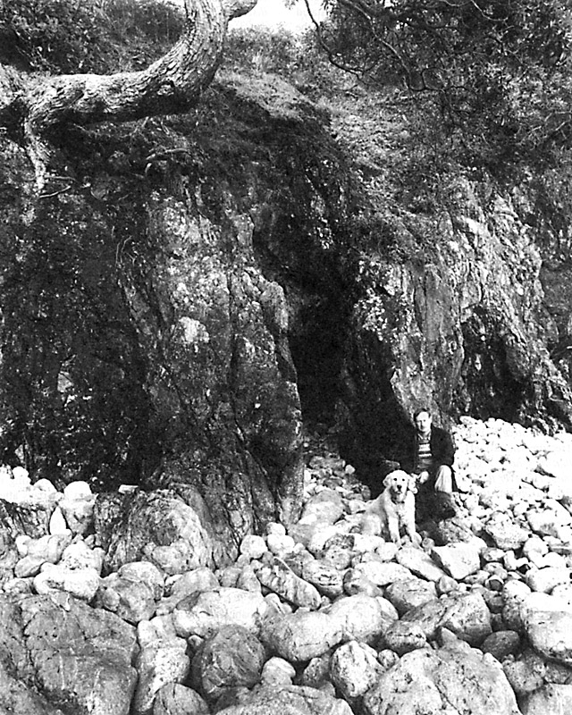
Entrance to the main adit at Oukori Bay, July 1996. The adit, which extends for about 110 metres along an east-west trending quartz vein, was probably opened up between 1894 and 1902. Photo: Lloyd Homer.
Sinking on the Treasure Island Reef
Ohinemuri Regional History Journal 43, September 1999
Little evidence now remains of the Waihi Beach Company's attempts at gold mining in the area. All the buildings and machinery have long gone, and the main shaft has been completely filled in. However, the shaft site is still clearly identifiable (from the associated excavation into the hillside), and the old access road, which was paved with pieces of quartz in places, now forms part of the Orokawa Bay walking track. Most of the small prospecting adits along the coastal cliffs are still in reasonably sound condition, particularly those at Oukori Bay.
Entrance to the main adit at Oukori Bay, July 1996. The adit, which extends for about 110 metres along an east-west trending quartz vein, was probably opened up between 1894 and 1902. Photo: Lloyd Homer.
[see also: Discovery of Gold at Waihi Beach in this Journal - E]