Ohinemuri Regional History Journal 48, September 2004
EARLY SETTLERS OF THE UPPER ROTOKOHU (SOUTH of PAEROA)
By B R Thorp
To begin with, it needs to be explained that the Rotokohu Road, up until 1900, was the main route south from the Thames-Waihi Goldfields, the most populous region in the North Island, after Auckland, so it was not surprising that this land was seen to be desirable for settlement, that is, the hill country, as all the flat land away from the rivers, was on unfarmable swamp.
This story begins in 1922. I will detail the owners/occupiers of the various surveyed blocks in the upper Rotokohu at that time. This story is also a microcosm of what happened all over New Zealand in the early days of settlement, right from the Wakefield schemes of 1838, and not too dissimilar. Such was the enthusiasm of would-be settlers, many bought blocks or allotments "off the plans" as it were, without ever inspecting the land, or even if there was any access to it. Some were genuine settlers, others mere speculators, who never set foot on the land. The following is a list of owners of each block, as at 1922, with brief details. The reason 1922 has been chosen for the study is that that year was the beginning of the end for all these owners (bar one). In other words, the end of an era.
Harry Hill: 304 acres not farmed, top of range, all bush, parts very steep, no access. Sold 1922.
J Clarkin: 400 acres not farmed, better land, all bush, no access, facing Te Aroha. Sold 1923.
Lands & Survey Department: 91 acres Government ownership, all bush, no access, facing south. Sold 1924.
Rihitoto Mataia: 29 acres not farmed, Maori/private ownership. Sold 1925.
Jim Brown: 439 acres, farmed. Sold 1934.
Dan Sheehan: 34 acres, farmed. Sold 1939.
Dave Sheehan: 208 acres farmed. Retained in family.
Barrett: 107 acres, farmed. Sold.
Costello: 378 acres, farmed. Sold 1942.
Nichols Brothers: 164 acres, logged but not farmed. Maori private ownership. Sold 1955.
Farming was at a very subsistence level, but the settlers were all super optimists. Yet everything was against them, except their enthusiasm. The land, when cleared of bush, was very stony and of low fertility. Soil could not be tilled without the removal of firstly stumps, then stones and boulders. Each settler hand milked from ten to twenty cows, with the usual associated farm livestock. Small mobs of goats were run in an attempt to control blackberry. On the larger blocks, sheep were run. Potatoes were grown, approximately three acres by Barrett, and one acre by Dan Sheehan, surplus produce being sold for cash, or traded in Paeroa. Native log sales and firewood provided some extra income.
1922
The first two on the above list, Harry Hill and J Clarkin, had by now realised that their land was impossible to farm, as the only access was by foot or horseback from Karangahake town, along a winding bridle track, around the eastern side of Karangahake Mountain, climbing to the main divide. This track was formed as it was the most direct route between the then flourishing gold mining towns of Karangahake and Te Aroha. Despite several "drives" for gold being put in, no gold-bearing quartz was found, so these two gentlemen happily quit their holdings in 1922 and 1923.
The other settlers
With low fertility, no fertiliser, no chemical technology to deal with weeds, the land gradually reverted to a mixture of hawthorn, barberry, blackberry, gorse, and natures own regenerator, tea tree. Only one settler survived - Dave Sheehan, who was able to convert his small cowshed to electricity, and bought an early model truck and began a cream run down Rotokohu Road, ending up at the New Zealand Co-operative factory in Paeroa. This block remained in the Sheehan family but is now in lifestyle blocks - the steeper land being retired to forestry. The last to sell was Costello, who hung on until 1942, as tea tree began to re-clothe the hard, steep hills.
It should be worthy of mention that there is evidence of one Maori family living in the area. (Maori villages were numerous around Paeroa, on the river banks.) Pori Kopa and his family had lived at the foot of the valley, and would have been there for at least several generations, as they established their own burial ground (urupa). A subsistence living it was, but made more agreeable by the cultivation of tobacco for their own use, the seed originally acquired by Maori from early European contacts. The seed is extremely viable and continues to flourish in 2004. Other essential crops were also grown in this sheltered spot - the site of my present residence and stockyards. Upon European settlement, this land became part of the Costello block of 378 acres, but excluding the burial ground.
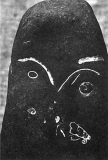
It is noteworthy that the early Government surveyors were careful to exclude Maori burial sites, so Pori Kopa's family burial ground is preserved in perpetuity. One unusual stone artefact found on this site has several carved koru indentations, filled with white silica, which is now in the Paeroa Museum. (See the photograph opposite.)
What of this land today? It is all being farmed, but only because of the huge research done on fertilisers, soil and pastures by New Zealand scientists, together with dedicated Department of Agriculture advisors, plus the advances in mechanisation, all of which the early settlers never had, but which enabled the Thorp brothers, Hal and Fielden, to redevelop this land into a viable sheep and cattle farm.

