Ohinemuri Regional History Journal 30, September 1986
By C. W. MALCOLM
Mrs IVY MEAD'S article on the Old Waihi Road in Journal 28 [see Journal 28: Old Waihi Road 1910-1925 - E] has stirred memories and started me off on this article and its accompanying sketch map. I have been much assisted by Mrs Mead's nephew, Mr E.J. (Ted) Hughes. Because of the passage of the years, and although I spent the first forty years of my life in the district, there are, between the three of us some slight conflicts of memory. However, before this interesting outlying part of the town is forever beyond recall, I feel some details should be recorded. Others may correct or add.
To me, living at the other extremity of the town, much of this area was terra incognita. We hurried through it furtively to fill our containers with the luscious blackberries that grew in profusion along Tarariki Stream, always known, for some reason, as Tackery's Creek. True or not, we believed that if the Inspector of Nuisances caught us he would destroy our harvest of blackberries with lime to prevent the spread of this noxious plant.
The Swimming Hole just above the bridge on the main Waihi Road, too, was often hurriedly visited in the school lunch hour. We did not know how the Ohinemuri River twisted and meandered beyond the road on its way to the town. Fellow pupils who sat with us at School seemed to dwell afar in a mysterious town beyond the bend in the road that once existed in the region of the Convent.
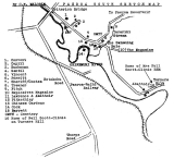
As the accompanying sketch map shows, many of Paeroa's notable and distinguished citizens once lived in this part of the town in days when a phenomenon not seen by the rest of Paeroa's residents was visible to them, Karangahake Mountain a fairyland of lights in the days of the gold mining boom.
It would be invidious in this article to comment on the part played in the history of the town by some of its citizens who lived in this area. However, one or two interesting features are historical. Where the figures 567 appear on the sketch map, Buchanan's Creek passed under the main road to its western side, parallelled the road for some distance, and finally turned west to enter the river. Between the creek and the river lay a "peninsula" of land on which three residences were built - Vincent's, Porritt's, and, I think, at one time Cootes's. Access to these houses from the road was by means of footbridges. The unfortunate habit of the Ohinemuri of flooding meant that these fine residences were from time to time subject to watery inundation.
A notable feature of the area was the elegant two-storeyed residence of the pioneer Cock Family (14 on sketch map), situated in a picturesque curve of the river and cut off by it from the road. The well-known daughters of the family crossed the river by canoe, took their bicycles from their building on the other side, and cycled into town, surely a romantic means of transit in those early days.
No. 13 on the sketch map shows the location of the Chinaman's large vegetable garden. I am fairly certain that at one time similar gardens were sited on the other side of the road somewhere between the properties of the Buchanans and Mr C.B. Gentil. From these marvellously well kept gardens a friendly Chinaman with horse and cart "did the rounds" of Paeroa's streets, our parents coming out from our homes to purchase from him the week's fresh vegetable supply.
Paeroa South Sketch Map.
1. Convent
2. Capill
3. Buchanan
4. Gentil
5. Vincent
6. Porritt
7. Sheriff/Cootes
8. Treanor
9. Fitch
10 Explosives Magazine
11 Lawrence & Abattoir
12 Pitkethley
13 Chinese Gardens
14 Cock
15 Barrett
CMTY - Cemetery
16 Home of Nell Scott-Climie on Turners Hill

