Ohinemuri Regional History Journal 44, September 2000
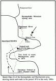
Prior to the opening of the goldfield in 1875, there were no roads in the Karangahake area. Many of the earliest gold seekers arrived at Paeroa by boat and then set out on foot for the goldfields. A road of sorts was soon formed between Paeroa and Mackaytown but it had to cross the Ohinemuri River twice, just before reaching Mackaytown. To avoid these crossings, a deviation over the hill (subsequently known as Turner's Hill) was formed in 1875 by a section of the army under the command of Captain Turner.
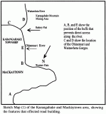
It is necessary to consider the natural features which had to be taken into account in building roads in the area and the areas the roads were to provide access to. Neither of these factors are obvious today - The need for access then was to the mining areas on the southern side of the river and the various bluffs which came right down to the river either on both sides or one side. These obstacles are indicated on "Sketch 1".The area marked as Battery Flat was the first area of settlement at Karangahake. The area on the northern side of the river became the main settled area after the mid 1880s. The mines were on the southern side of the river hence the settlement started there. Battery Flat was the site of the first hotel, store, battery, post-office and other facilities.
The original road through Mackaytown from Paeroa to Waitekauri went through the Rahu Valley and over the saddle north of the White Rocks. On reaching the saddle the road continued and bypassed Waikino through the hills to the north, ultimately reaching the Waitekauri mines. Later (1880s), it descended near Owharoa to join the main Paeroa-Waihi Road. A branch track led to the Old Tauranga Road, and to Katikati. Obviously the "road" then was merely a track. Ways and means were explored of finding an easier route but it was considered that a road through the Gorge would be an impossibility.
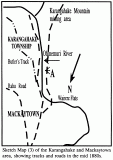
From the time of the opening of the goldfield until the late 1880s, the condition of the various tracks serving the mines was so bad that during the winter months each year, mining came to a standstill. During these very early years before the installation of tramways, the only way to transport the ore from the mines to the battery was for it to be carted on men's backs. Prior to 1885, when Ohinemuri became a separate County, the Thames County had a riding track put over the hills from near Doherty's Creek and graded up to pass over the Bluff above the Gorge and down again to Owharoa. It was known as Butler's Track, after the contractor, Hugh Butler. Another area requiring access was the flat along the river, now known as River Road. This was first reach by a track sloping down from the Woodstock Road to the river. Remains can still be seen of this track today in the vicinity of the spot marked "A" on the sketch numbered (3). Later a road was formed down Corne's Gully. (This road, now known as Crown Hill, has widened over the years and was tarsealed in the1970s).
In April 1896 a report on the Rahu Road stated, "The horses became completely bogged in many places and the other day pieces were pulled out of a coach in endeavouring to drag it through." For sometime the main road from Paeroa to Karangahake was not formed beyond Doherty's Creek and although one could cross the river there by a small boat pulled across by a heavy wire, the ford opposite Mackaytown was the main gateway to the mining area. Soon after the opening of the Goldfield, the Thames County constructed Woodstock Road from the ford towards the Mountain. This road later became known as Number 8 Road because it lead to the Talisman Mine No. 8 level. There were various side roads, one leading to the Crown Mine Battery and one leading to Rotokohu Valley and on to Te Aroha. Yet another side road lead down Scotchmans Gully. Part of the former Woodstock Road is now called County Road.
The bluffs near the present tunnel were cut back in 1886 giving direct access to Karangahake township via Doherty's Creek. After the completion of the double-decker road/rail bridge in 1903, the Mackaytown ford fell into disuse and the "side road" known as Crown Hill provided the main access to the upper reaches of the west side of the river. With the passing of the years the various other side roads, such as Scotchmans Gully, became impassable.
For many years the township of Karangahake was the end of the road, further progress barred by the precipitous Gorge. It was not until the late 1880s that the road through the Gorge was formed. Opened in 1891, this was a very narrow road and there were often incidents along it. There were few places to pass and heavier traffic was timed to pass through in a convoy. Traction engines were used to haul heavy wagons from Paeroa to Waihi in the pre railway days of the 1900s. The original road was put through by the Ohinemuri County - workmen were sometimes suspended in cages over the steep cliff faces and blasting rock in such circumstances must have been very difficult. During the 1930s the Main Highway's Board which had operated since 1924 widened the Gorge Road. During this period of widening the traffic was diverted over the Rahu Saddle. The Main road through Karangahake was tarsealed in the 1940s and during the 1960s the old pavement curbing through the township was ripped out to allow road widening. In the early 1970s the road over Turner's Hill to Mackaytown was realigned, then during 1983/ 85 the bluffs by the tunnel were cut back and further road improvements carried out.
BRIDGES
Two more swing bridges were erected, one in 1906, near Doherty's Creek, to link Mackaytown with the Bowling Greens and School of Mines (end of River Road), and another, to link Mackaytown Railway side station with the Mackaytown Domain. These swing bridges remained until damaged by floods in February 1936. A large heavy trestle bridge, replacing the first swing bridge at Karangahake township was built in 1912. This remained until the mid 1950s and the present pipeline bridge was built on the same site in 1958. The concrete centre pier of the trestle bridge still remains.
There were a number of bridges crossing the Waitawheta River which were for mining purposes (at least six). These deteriorated after 1920. In 1958 a new swing bridge was built across the Waitawheta near the Woodstock mine to carry the Paeroa water supply pipe. A further swing bridge was built in 1986 to form the Walkway link.


