Ohinemuri Regional History Journal 37, September 1993
PAEROA'S TRAMWAY
[see also below: Paeroa's Tram-car, Information Regarding the Paeroa Tramway, Another Junction Road Tramway, and in this Journal: Paeroa Tramway - E]
By CW Malcolm
The Hauraki Plains Gazette (now Paeroa Gazette) of 28 July, 1950, has an article headed, "When Paeroa had Trams Over 50 Years Ago" and shows photographs of the tram rails along Normanby Road and Belmont Road. It states that they ran from the Junction Wharf at the confluence of the Waihou and Ohinemuri Rivers to the Criterion Hotel.
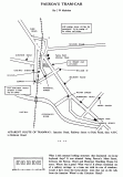
Boyhood memories are vivid. We vacated our Rye Lane (now Towers Street) home in the flood of 1910 and while our new home was being erected at the top of Hill Street in 1911, we lived temporarily in a small cottage at the bend in what is now Marshall Street. There existed (see xx on the map, following page.) a grass-grown metalled section of roadway used merely as a walking short-cut from Marshall Street to Belmont Road. This, I feel sure, must have been part of Junction Road before it had to be diverted because of the construction of the Railway Station where it was first situated.
One other memory of my time as a small boy spent in that locality concerns the section on the comer of William Street and Marshall Street. At the time it was vacant but had a collection of discarded "scrap" metal. One object, for some reason, always attracted my attention and held my interest; it was a pair of flanged wheels attached to their sturdy axle. Could this have been part of that tram, such an historic part of the town's history, so carelessly discarded, so soon forgotten?
PAEROA'S TRAM-CAR
By C W Malcolm
APPARENT ROUTE OF TRAMWAY: Junction Road, Railway Street to Puke Road, then A-B-C to Belmont Road.
What is this unusual looking structure that fascinated me in my boyhood days? It was situated facing Paeroa's Main Street, between the Paeroa Hotel and Montrose Boarding House for years. Where has it gone? What was it? It always reminded me of a railway carriage or a tram car with its row of windows. Could it have been the horse-drawn tram that ran on the rails from the Junction Wharf to the Criterion Hotel?
INFORMATION REGARDING THE PAEROA TRAMWAY
By Ian Parlane
I fully agree with Mr C W Malcolm in regard to the questions he has raised on page 37 Journal 36 [see Journal 36: Paeroa's Tram Car - E] re the Paeroa Tramway.
With the generous courtesy and help of Mr Vaughan Baker, surveyor, of Paeroa, I was able to see some of the early survey plans of the area, and the following inferences follow from that inspection.
1. The NZ Railways had acquired the land for permanent way and station prior to 1887 for a plan dated early in 1887 shows the laying off of the deviation of Belmont Road - Puke Road past what is now the Caltex Service Station.
2. The plan showing the survey and dedication of the south-western end of Station Road is dated 18 January 1894 which would be close to the date of construction of the station. If the station had not by then been built it is probable that its impending construction would have been public knowledge. Station Road is surveyed to intersect with the aforementioned "deviation".
3. Marshall Street between Hughenden Street and approximately the St. John Ambulance quarters was originally part of Junction Road. When the railway came it created a "level crossing" at the bend. When the stopbanks came in 1924-25 the railway bridge was raised and the railway embankment formed, the Junction Road level crossing was closed and the William Street subway constructed to replace that closed crossing. The severed portion of Junction Road on the "town" side of the embankment was thereafter referred to as Junction "Street" to give it some differention but this did not really remove the confusion for doctors, taxis and visitors. In the early 1950's the Borough Council arranged the dedication and formation of part of the railway reserve land as street between the St. John Ambulance premises and the ex-Karangahake band rotunda. About the same time the street had been extended towards the east between Hughenden Street and Wharf Street (following the destruction by fire of the "Doll Factory" and the removal of a house to a new site in Towers Street.) About 1957 the whole length from Wharf Street to the band rotunda was renamed "Marshall Street" honouring the contribution made by former Mayor William Marshall (1923-41).
4. A photo at the Museum shows the tramlines running almost the full length of Belmont Road but it is my guess that the tramline came from the wharf up Junction Road to the St. John Ambulance building, then turned along Marshall Street (at the rear of the supermarket), then turned left into William Street and right into Belmont Road (where the wagons would have been adjacent to the Brenan & Co. premises) before continuing on up to the vicinity of the Criterion Hotel.
5. (EDITORS NOTE: The information in this paragraph relates to the later tramway. See also the article "Another Paeroa Tram".[see below - E])
I do not know when this service ceased but recall reading somewhere that coal had been carted from the railway station to the Waihi-Paeroa gold extraction works by the tramway down Junction Road and left into what is now Maori Road and from there across Pereniki Bend from where it was conveyed by aerial cable over the Ohinemuri River to the Extraction Works. The Extraction works operated between 1912 and 1918 and it would seem probable that the tramway ceased when the works closed. (The wharf had long since moved to Puke.) Lending credence to this supposition is that the Junction Road - Maori Road intersection has a surveyed "corner splay" - the only one on any early Paeroa survey plan. A corner splay would facilitate a smooth curve for a tram track.
6. Coincidental to the foregoing is the question of the spelling of HUGHENDEN street. The name is more often than not mis-spelled. The street name signs compound this mistake. This street is named after Hughenden Manor, a small town nestled at the foot of the Chiltern Hills in Buckinghamshire, about 25 miles from London. It is located in the (English) Thames Valley near High Wycombe and not very far from Windsor Castle. The naming of this street is clearly shown on the Ingham Stephens 1884 survey plan lodged as D.P. 247.
ANOTHER JUNCTION ROAD TRAMWAY
By C W Malcolm
Along the south side of Junction Road once ran the two iron rails of a tramway that had nothing to do with the passenger-carrying trams that linked the Junction Wharf with Paeroa's Main Street as far as the Criterion Hotel.
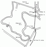
This later tramway began in the yards of Paeroa's first Railway Station (RR) at a siding (1) where coal was unloaded from railway wagons. Much of this coal was transferred to horse-drawn trucks which then proceeded along the rails on Junction Road (2 - 3) where they turned south (via 4) until they reached the Ohinemuri River (at 5), opposite the Paeroa - Waihi Gold Extraction Works.
At this point (5) the coal was placed in hoppers from which it was conveyed by aerial cable across the river to the Works as fuel for the machinery employed to extract the gold from the silt dredged from the river bed - gold that escaped the batteries higher up the Ohinemuri before they had perfected the processing with cyanide.
Also crossing the river at this point was a foot-bridge and it was by this route that most of Paeroa's men employed at the Works made their way by foot or bicycle to their work. We children, too, fascinated by this large industrial plant, made our way there by the same means. There is an illustrated article regarding the Works in Journal 30.
Where the subway is indicated was once a level crossing at the south end of the railway station.


