Waihi Street Names
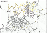
Information about Waihi streets has been taken from modern data, and from early Borough maps. Changes to some street names and numbering were undertaken by Council in March 2016. An attempt has been made to show these changes in the map below.

The yellow lines denote streets or roads (or parts of) that no longer exist, or are not used today. The base map shows the boundaries of our current roads (formed or unformed) derived from HDC cadastral data.
Waihi Street Names
When you open the larger image, be sure to click on the 1:1 button so as to see the full size image. You may have to drag the image out of the way to find this button (amongst the slide show buttons at bottom of screen). You can then use the mouse to drag the the map about to see its full extent.
The yellow lines denote streets or roads (or parts of) that no longer exist, or are not used today. Some are still unformed legal roads. The base map shows the boundaries of our current roads (formed or unformed) derived from HDC cadastral data.
